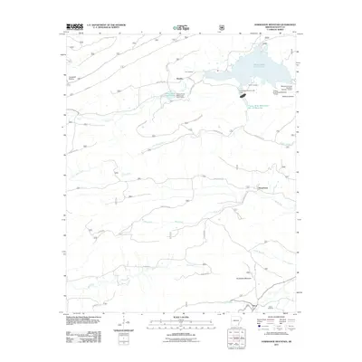
2011 Map of Horseshoe Mountain
USGS Topo · Published 2011About this map
Horseshoe Mountain rises as the dominant landform in this southern Scott County landscape, where the headwaters of several significant drainages converge. The map documents a rural network of small communities including Brawley, Beauchamp, and Tintop, connected by forest roads and winding county lanes such as Hickory Valley Rd and Tintop Rd. Water management is a primary feature of the terrain, evidenced by numerous flood control structures like the Poteau River Site 13 Lake and the Poteau River Watershed Site 12 Reservoir, reflecting a 20th-century history of watershed conservation in the Ouachita region. For genealogists, the map identifies several burial sites including Vise Cemetery, Oliver Cemetery, and Slover Cemetery, which serve as physical markers of the area's family histories. The drainage patterns of Black Fork and Denton Creek illustrate the valley systems that have historically dictated the placement of homesteads and small-scale agriculture in this part of Arkansas.
Find a feature on this map
39 named features on this map. Tap any name to fly to it.
Don’t see what you’re looking for? This feature index may not catch every label — zoom into the map to look around manually.
Map Details
Editions of this 2011 Horseshoe Mountain Map
This is the sole edition of this map. No revisions or reprints were ever made.
Other maps of this area

1879 · Poteau Mountain
USGS Topo · 1:62,500

1887 · Poteau Mountain #1
USGS Topo · 1:62,500

1887 · Poteau Mountain #2
USGS Topo · 1:62,500

1890 · Poteau Mountain
USGS Topo · 1:125,000

1899 · Poteau Mountain
USGS Topo · 1:125,000

1939 · Waldron
USGS Topo · 1:62,500

1940 · Waldron
USGS Topo · 1:62,500

1941 · Waldron
USGS Topo · 1:62,500

1949 · Waldron
USGS Topo · 1:62,500

1950 · Mcalester
USGS Topo · 1:250,000