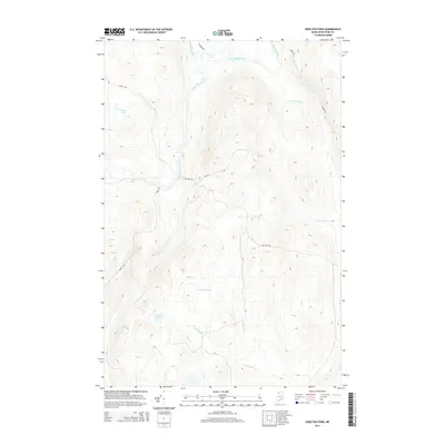
2014 Map of Houlton Pond
USGS Topo · Published 2014About this map
Houlton Pond and the surrounding timberlands of Aroostook County are defined by a complex network of waterways and logging roads in the northern Maine woods. This 2014 survey documents the drainage patterns of the Big Black River, which receives the waters of Depot Stream, Conners Brook, and White Brook. The landscape is largely undeveloped, with road systems such as Depot Rd and Nine Mile Rd providing the primary access through the high-elevation terrain between the river valleys.
Find a feature on this map
13 named features on this map. Tap any name to fly to it.
Don’t see what you’re looking for? This feature index may not catch every label — zoom into the map to look around manually.
Map Details
Editions of this 2014 Houlton Pond Map
This is the sole edition of this map. No revisions or reprints were ever made.
Other maps of this area

1954 · Presque Isle
USGS Topo · 1:250,000

1955 · Depot Lake
USGS Topo · 1:62,500

1955 · Beaver Pond
USGS Topo · 1:62,500

1955 · Clayton Lake
USGS Topo · 1:62,500

1955 · Seven Islands
USGS Topo · 1:62,500

1958 · Presque Isle
USGS Topo · 1:250,000

1960 · Presque Isle
USGS Topo · 1:250,000

1976 · Seven Islands
USGS Topo · 1:24,000

1976 · Depot Lake
USGS Topo · 1:24,000
1976 · St. Pamphile
USGS Topo · 1:24,000