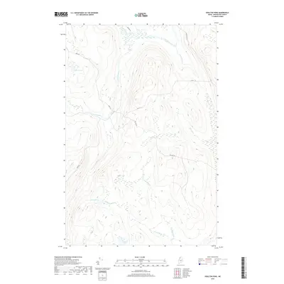
2018 Map of Houlton Pond
USGS Topo · Published 2018About this map
Big Black River flows across the northern reaches of this territory, defining a landscape shaped by the intricate drainage of Depot Stream and Conners Brook. The area is characterized by isolated water bodies and a network of logging and access roads that penetrate the dense woods of northern Maine. Houlton Pond sits in the southwestern quadrant, connected to the broader watershed by Houlton Brook, while the distinctively named Blood Lake occupies a high basin to the northwest. The presence of named routes like Depot Rd and Nine Mile Rd reflects the long-standing timber and transport history of this portion of Aroostook County. These corridors provide the primary access to the various wetlands and secondary waterways, including Fourmile Brook and White Brook, which carve through the varying elevations of the terrain.
Find a feature on this map
13 named features on this map. Tap any name to fly to it.
Don’t see what you’re looking for? This feature index may not catch every label — zoom into the map to look around manually.
Map Details
Editions of this 2018 Houlton Pond Map
This is the sole edition of this map. No revisions or reprints were ever made.
Other maps of this area

1954 · Presque Isle
USGS Topo · 1:250,000

1955 · Depot Lake
USGS Topo · 1:62,500

1955 · Beaver Pond
USGS Topo · 1:62,500

1955 · Clayton Lake
USGS Topo · 1:62,500

1955 · Seven Islands
USGS Topo · 1:62,500

1958 · Presque Isle
USGS Topo · 1:250,000

1960 · Presque Isle
USGS Topo · 1:250,000

1976 · Seven Islands
USGS Topo · 1:24,000

1976 · Depot Lake
USGS Topo · 1:24,000
1976 · St. Pamphile
USGS Topo · 1:24,000