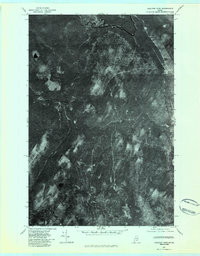
1977 Map of Houlton Pond
USGS Topo · Published 1983About this map
Big Black River meanders across the northern reaches of this orthophotoquad, defining a heavily forested and water-dominated landscape in Aroostook County. This 1977 aerial perspective captures the region before modern digital mapping, showcasing a dense network of waterways including Depot Stream and White Brook. The imagery reveals the intricate textures of the Maine woods, where isolated water bodies like Blood Lake and Houlton Pond sit within a terrain marked by varying stages of timber growth and natural drainage patterns. The course of Fourmile Brook and Houlton Brook further illustrates the complex watershed that feeds the larger river systems of the north woods. Because this is an orthophotograph rather than a traditional line map, it offers researchers a rare literal view of the vegetation and land use patterns at the time of the flyover.
Find a feature on this map
7 named features on this map. Tap any name to fly to it.
Don’t see what you’re looking for? This feature index may not catch every label — zoom into the map to look around manually.
Map Details
Editions of this 1977 Houlton Pond Map
This is the sole edition of this map. No revisions or reprints were ever made.
Other maps of this area

1954 · Presque Isle
USGS Topo · 1:250,000

1955 · Depot Lake
USGS Topo · 1:62,500

1955 · Beaver Pond
USGS Topo · 1:62,500

1955 · Clayton Lake
USGS Topo · 1:62,500

1955 · Seven Islands
USGS Topo · 1:62,500

1958 · Presque Isle
USGS Topo · 1:250,000

1960 · Presque Isle
USGS Topo · 1:250,000

1976 · Seven Islands
USGS Topo · 1:24,000

1976 · Depot Lake
USGS Topo · 1:24,000
1976 · St. Pamphile
USGS Topo · 1:24,000