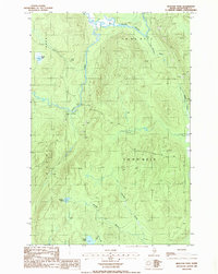
1986 Map of Houlton Pond
USGS Topo · Published 1986About this map
The Big Black River flows through this remote section of Aroostook County, carving a path through a landscape defined by its network of water bodies and timber-access routes. As shown in this mid-1980s provisional survey, the terrain is dominated by high-latitude hydrology, including Houlton Pond and Blood Lake. The presence of several Gravel Pits along the Depot Stream and scattered Private Roads suggests the ongoing importance of the logging industry during this period. Defined by the administrative boundaries of T 14 R 15 W E L S and neighboring townships, the area remains largely unpopulated, focused on resource extraction and the natural drainage patterns of Conners Brook and Fourmile Brook. This sheet provides a clear record of the seasonal water systems and the industrial infrastructure necessary to navigate this north woods environment.
Find a feature on this map
16 named features on this map. Tap any name to fly to it.
Don’t see what you’re looking for? This feature index may not catch every label — zoom into the map to look around manually.
Map Details
Editions of this 1986 Houlton Pond Map
This is the sole edition of this map. No revisions or reprints were ever made.
Other maps of this area

1954 · Presque Isle
USGS Topo · 1:250,000

1955 · Depot Lake
USGS Topo · 1:62,500

1955 · Beaver Pond
USGS Topo · 1:62,500

1955 · Clayton Lake
USGS Topo · 1:62,500

1955 · Seven Islands
USGS Topo · 1:62,500

1958 · Presque Isle
USGS Topo · 1:250,000

1960 · Presque Isle
USGS Topo · 1:250,000

1976 · Seven Islands
USGS Topo · 1:24,000

1976 · Depot Lake
USGS Topo · 1:24,000
1976 · St. Pamphile
USGS Topo · 1:24,000