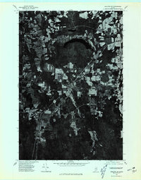
1975 Map of Houlton SW
USGS Topo · Published 1980About this map
Linneus and New Limerick anchor this 1975 orthophoto survey of southern Aroostook County, where the agricultural grid of Maine’s potato country meets the dense northeastern forests. The imagery provides a clear view of the rural landscape before modern development, showing the distinct patchwork of cleared fields and woodlots that defined the local economy during the mid-1970s. Waterways like the Meduxnekeag River and its South Branch cut through the terrain, with Glancy Lake serving as a prominent landmark in the northern section of the sheet. For those researching family homesteads or land-use history in this border region, the map offers an unfiltered look at road networks and individual farmstead clearings at a scale that captures the fine-grained texture of the rural Maine landscape.
Find a feature on this map
5 named features on this map. Tap any name to fly to it.
Don’t see what you’re looking for? This feature index may not catch every label — zoom into the map to look around manually.
Map Details
Editions of this 1975 Houlton SW Map
This is the sole edition of this map. No revisions or reprints were ever made.
Other maps of this area

1937 · Smyrna Mills
USGS Topo · 1:62,500

1938 · Houlton
USGS Topo · 1:62,500

1940 · Amity
USGS Topo · 1:62,500

1941 · Amity
USGS Topo · 1:62,500

1941 · Mattawamkeag Lake
USGS Topo · 1:62,500

1943 · Amity
USGS Topo · 1:62,500

1943 · Mattawamkeag Lake
USGS Topo · 1:62,500

1951 · Houlton
USGS Topo · 1:62,500

1954 · Presque Isle
USGS Topo · 1:250,000

1954 · Millinocket
USGS Topo · 1:250,000