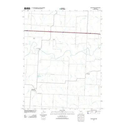
2011 Map of Houstonia
USGS Topo · Published 2011About this map
Houstonia sits at the southwestern edge of this landscape, a region defined by the winding course of the Blackwater River and its numerous tributaries. Just north of the town, the river creates a complex riparian corridor, supported by landmarks like the McAllister Springs Access Point and Shanz-Stockman Spring. The terrain rises gently toward the north at Coppers Hill, while the surrounding prairie is divided into a geometric grid of county roads and family-named routes such as Schondeimaier Rd and Chamberlin Rd. This rural layout reveals a deeply established agricultural community, with the small settlement of Tedieville situated to the east. Local heritage is preserved at the Houstonia Cemetery and Rose Valley Cemetery, while the presence of Raymond Wicker Lake and Buffalo Creek indicates the importance of water management in this Pettis County setting during the early 21st century.
Find a feature on this map
41 named features on this map. Tap any name to fly to it.
Don’t see what you’re looking for? This feature index may not catch every label — zoom into the map to look around manually.
Map Details
Editions of this 2011 Houstonia Map
This is the sole edition of this map. No revisions or reprints were ever made.
Other maps of this area

1887 · Sedalia
USGS Topo · 1:125,000

1890 · Marshall
USGS Topo · 1:125,000

1892 · Marshall
USGS Topo · 1:125,000

1894 · Sedalia
USGS Topo · 1:125,000

1901 · Marshall
USGS Topo · 1:125,000

1939 · Sweet Springs
USGS Topo · 1:62,500

1940 · Sweet Springs
USGS Topo · 1:62,500

1940 · Marshall
USGS Topo · 1:62,500

1941 · Sweet Springs
USGS Topo · 1:62,500

1944 · Marshall
USGS Topo · 1:62,500