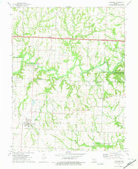
1973 Map of Houstonia
USGS Topo · Published 1975About this map
Houstonia and the surrounding borderlands of Saline and Pettis Counties are detailed in this early 1970s survey. The landscape is defined by the winding course of the Blackwater River, which supports the Marshall Junction State Wildlife Area and provides local access at the McAllister Springs Access Point. This era shows a community in transition, where an Old Railroad Grade remains visible south of town, marking the path of former rail commerce through Houstonia toward the local Sewage Disposal Pond. Local genealogy is well-represented through several rural landmarks, including the Corinth Christ Ch and the Rose Valley Cem. Terrain features like Coppers Hill rise above the drainage basins of Salt Pond Creek and Buffalo Creek, while the presence of a Quarry and numerous bench marks suggests the active surveying and industrial utility of the Missouri interior during this period.
Find a feature on this map
34 named features on this map. Tap any name to fly to it.
Don’t see what you’re looking for? This feature index may not catch every label — zoom into the map to look around manually.
Map Details
Editions of this 1973 Houstonia Map
This is the sole edition of this map. No revisions or reprints were ever made.
Other maps of this area

1887 · Sedalia
USGS Topo · 1:125,000

1890 · Marshall
USGS Topo · 1:125,000

1892 · Marshall
USGS Topo · 1:125,000

1894 · Sedalia
USGS Topo · 1:125,000

1901 · Marshall
USGS Topo · 1:125,000

1939 · Sweet Springs
USGS Topo · 1:62,500

1940 · Sweet Springs
USGS Topo · 1:62,500

1940 · Marshall
USGS Topo · 1:62,500

1941 · Sweet Springs
USGS Topo · 1:62,500

1944 · Marshall
USGS Topo · 1:62,500