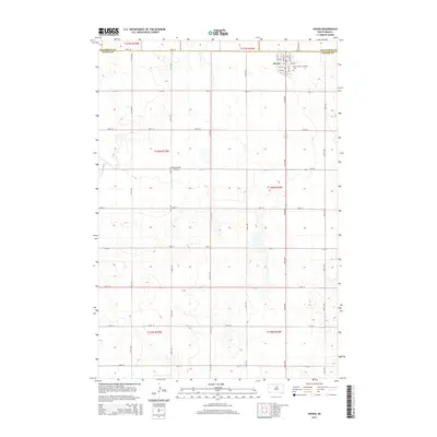
2015 Map of Hoven
USGS Topo · Published 2015About this map
Hoven serves as the primary hub of activity in this 2015 survey, situated at the boundary of Potter Co and Walworth Co. The town is characterized by a precise grid of streets, including Ogorrman St and Marsh St, and is anchored by the Saint Anthony Catholic Cem. Outside the immediate settlement, the landscape transitions into a vast expanse of agricultural sections and township lines, where the Monty Harer Airstrip stands as a notable rural landmark. The map illustrates a highly organized rural infrastructure, where long thoroughfares like 319th Ave and 148th St delineate the South Dakota plains, reflecting a modern era of mechanized farming and regional connectivity.
Find a feature on this map
32 named features on this map. Tap any name to fly to it.
Don’t see what you’re looking for? This feature index may not catch every label — zoom into the map to look around manually.
Map Details
Editions of this 2015 Hoven Map
This is the sole edition of this map. No revisions or reprints were ever made.
Other maps of this area

1954 · Aberdeen
USGS Topo · 1:250,000

1956 · Aberdeen
USGS Topo · 1:250,000

1974 · Lowry
USGS Topo · 1:24,000

1974 · Hoven
USGS Topo · 1:24,000

1974 · Hoven Muni. Airport
USGS Topo · 1:24,000
1974 · Flight Lake
USGS Topo · 1:24,000
1978 · Gettysburg
USGS Topo · 1:24,000

1978 · Seneca NW
USGS Topo · 1:24,000
1978 · Seneca SW
USGS Topo · 1:24,000

1978 · Bowdle SW
USGS Topo · 1:24,000