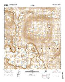
2015 Map of Howard Pass A-5 SE
USGS Topo · Published 2015About this map
Noatak National Preserve encompasses the entirety of this Arctic landscape, where the wide meanders of the Noatak River dominate the southern half of the quadrangle. A significant geographic feature is the Okak Bend, a pronounced oxbow curve where the river pivots sharply against the rising terrain to the north. This high-latitude environment is characterized by the complex drainage of Makpik Cr, which flows southward from the hills to join the primary river system. The 2015 survey illustrates the path of these waterways across a roadless wilderness, providing a clear view of the natural hydrology and topographical contours within the western Brooks Range foothills.
Find a feature on this map
10 named features on this map. Tap any name to fly to it.
Don’t see what you’re looking for? This feature index may not catch every label — zoom into the map to look around manually.
Map Details
Editions of this 2015 Howard Pass A-5 SE Map
This is the sole edition of this map. No revisions or reprints were ever made.
Other maps of this area

1951 · Howard Pass
USGS Topo · 1:250,000

1951 · Ambler River
USGS Topo · 1:250,000

1956 · Howard Pass
USGS Topo · 1:250,000

1956 · Ambler River
USGS Topo · 1:250,000

1964 · Ambler River
USGS Topo · 1:250,000
1990 · Howard Pass A-4
USGS Topo · 1:63,360
1990 · Ambler River D-6
USGS Topo · 1:63,360
1990 · Howard Pass A-5
USGS Topo · 1:63,360
1990 · Ambler River D-5
USGS Topo · 1:63,360
2015 · Ambler River D-5 NW
USGS Topo · 1:25,000