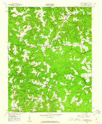
1944 Map of Howertons
USGS Topo · Published 1961About this map
Millers Tavern serves as a central crossroads on this mid-century survey, where the boundary between Essex Co and King and Queen Co bisects the rural landscape. The map reveals a community defined by its watercourses and small social centers, such as Bruington and Howertons. The hydrology is particularly striking, dominated by the winding expanse of Dragon Swamp to the east and Wrights Millpond near the center of the sheet. Numerous small educational and religious landmarks are documented, including the John Moncure Sch, Beulah Sch, and Smyrna Ch. These features illustrate the decentralized settlement pattern of the Virginia Tidewater region during the 1940s, showing a network of hamlets like Henleys Fork and Bestland connected by winding secondary roads that follow the drainage divides of Piscataway Creek and Fleets Creek.
Find a feature on this map
33 named features on this map. Tap any name to fly to it.
Don’t see what you’re looking for? This feature index may not catch every label — zoom into the map to look around manually.
Map Details
Editions of this 1944 Howertons Map
This is the sole edition of this map. No revisions or reprints were ever made.
Other maps of this area

1918 · Tappahannock
USGS Topo · 1:62,500

1918 · Aylett
USGS Topo · 1:62,500

1919 · New Kent
USGS Topo · 1:62,500

1919 · Tappahannock
USGS Topo · 1:62,500

1920 · King William
USGS Topo · 1:62,500

1933 · Aylett
USGS Topo · 1:62,500

1943 · Richmond
USGS Topo · 1:250,000

1944 · Mount Landing
USGS Topo · 1:31,680

1944 · Tappahannock
USGS Topo · 1:31,680

1944 · Dunnsville
USGS Topo · 1:31,680