
1959 Map of Hualalai
USGS Topo · Published 1960About this map
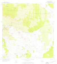
Hualalai dominates this mid-century survey of the North Kona District, where volcanic topography dictates the patterns of settlement and land use. The map illustrates a complex landscape of prehistoric and historic features, including the Ahu a Umi Heiau and the prominent Lava Flow of 1859 cutting across the northeastern terrain. Much of the high-elevation area is preserved within the Hualalai Forest Reserve, characterized by numerous cinder cones and craters such as Hainoa Crater and Puu Honuaula. Human activity is marked by an extensive system of fence lines and remote trails, most notably the historic Judd Trail crossing the Keauhou 2 land division. Small, scattered names like Shangri-la and Kalamalu dot the landscape near Potato Hill, providing a snapshot of the region's isolated ranching and agricultural outposts before modern expansion.
Find a feature on this map
52 named features on this map. Tap any name to fly to it.
Don’t see what you’re looking for? This feature index may not catch every label — zoom into the map to look around manually.
Map Details
Editions of this 1959 Hualalai Map
2 editions found
Other maps of this area

1927 · Kaohe
USGS Topo · 1:62,500

1928 · Puako
USGS Topo · 1:62,500

1928 · Kailua
USGS Topo · 1:62,500

1930 · Kaohe
USGS Topo · 1:62,500

1954 · Hawaii North
USGS Topo · 1:250,000

1956 · Keamuku
USGS Topo · 1:24,000

1956 · Puu O Uo
USGS Topo · 1:24,000

1956 · Naohueleelua
USGS Topo · 1:24,000

1959 · Hawaii North
USGS Topo · 1:250,000

1959 · Kiholo
USGS Topo · 1:24,000