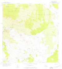
1959 Map of Hualalai
USGS Topo · Published 1976About this map
Ahu a Umi Heiau stands as a significant cultural landmark on the slopes of the dormant shield volcano Hualalai in this 1959 field-checked survey. The landscape is defined by extensive lava flows and various cinder cones, including Puu Honuaula and Puu o Mawae. The map documents the transition from the forested upper elevations of the Kaupulehu Forest Reserve to the lower rangelands and ahupuaʻa divisions like Keauhou 2 and Puu Anahulu.
Find a feature on this map
53 named features on this map. Tap any name to fly to it.
Don’t see what you’re looking for? This feature index may not catch every label — zoom into the map to look around manually.
Map Details
Editions of this 1959 Hualalai Map
2 editions found

Other maps of this area

1927 · Kaohe
USGS Topo · 1:62,500

1928 · Puako
USGS Topo · 1:62,500

1928 · Kailua
USGS Topo · 1:62,500

1930 · Kaohe
USGS Topo · 1:62,500

1954 · Hawaii North
USGS Topo · 1:250,000

1956 · Keamuku
USGS Topo · 1:24,000

1956 · Puu O Uo
USGS Topo · 1:24,000

1956 · Naohueleelua
USGS Topo · 1:24,000

1959 · Hawaii North
USGS Topo · 1:250,000

1959 · Kiholo
USGS Topo · 1:24,000