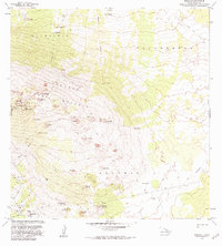
1982 Map of Hualalai
USGS Topo · Published 1984About this map
Kaupulehu Forest Reserve and the expansive reaches of Puuwa Awaa define the interior of the North Kona District in the early 1980s. This survey, updated with aerial photography, reveals the complex volcanic terrain through its numerous cinder cones and craters, including Hainoa Crater, Waha Pele, and Puu Honuaula. The presence of the Ahu a Umi Heiau landmark and the historic Judd Trail cutting across the Keauhou 2 region provides a look at the cultural and transit history of the island's high slopes.
Find a feature on this map
46 named features on this map. Tap any name to fly to it.
Don’t see what you’re looking for? This feature index may not catch every label — zoom into the map to look around manually.
Map Details
Editions of this 1982 Hualalai Map
2 editions found
Other maps of this area

1927 · Kaohe
USGS Topo · 1:62,500

1928 · Puako
USGS Topo · 1:62,500

1928 · Kailua
USGS Topo · 1:62,500

1930 · Kaohe
USGS Topo · 1:62,500

1954 · Hawaii North
USGS Topo · 1:250,000

1956 · Keamuku
USGS Topo · 1:24,000

1956 · Puu O Uo
USGS Topo · 1:24,000

1956 · Naohueleelua
USGS Topo · 1:24,000

1959 · Hawaii North
USGS Topo · 1:250,000

1959 · Kiholo
USGS Topo · 1:24,000