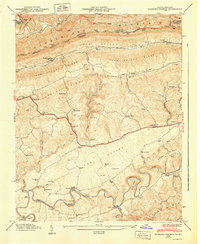
1947 Map of Hubbard Springs
USGS Topo · Published 1949About this map
Cumberland Mountain forms a dramatic northern wall for this Virginia-Kentucky borderlands area, where the Kentucky Virginia Divide follows the high ridge line. The landscape is defined by the tight parallel ridges of Poor Valley Ridge and Chestnut Ridge, through which the Louisville and Nashville railroad winds its way toward the Wagonroad Tunnel. This post-war survey illustrates a rural mountain economy deeply tied to the land, with numerous family-named landmarks such as the Wynn Cem, Spangler Cem, and Mc Clure Cem scattered near the Boone Trail. In the south, the Powell River carves a meandering path through The Cedars, creating distinctive features like Wilder Bend and Natural Bridge. The map serves as a detailed record of local civic life, capturing several remote educational and religious centers including Low Gap Sch, Maple Hill Sch, and Russell Chapel.
Find a feature on this map
102 named features on this map. Tap any name to fly to it.
Don’t see what you’re looking for? This feature index may not catch every label — zoom into the map to look around manually.
Map Details
Editions of this 1947 Hubbard Springs Map
This is the sole edition of this map. No revisions or reprints were ever made.
Other maps of this area

1887 · Jonesville
USGS Topo · 1:125,000

1891 · Jonesville
USGS Topo · 1:125,000

1903 · Harlan
USGS Topo · 1:48,000

1916 · Harlan
USGS Topo · 1:48,000

1916 · Nolansburg
USGS Topo · 1:48,000

1919 · Nolansburg
USGS Topo · 1:62,500

1919 · Harlan
USGS Topo · 1:62,500

1932 · Hagan
USGS Topo · 1:62,500

1935 · Kyles Ford
USGS Topo · 1:24,000

1935 · Hubbard Springs
USGS Topo · 1:24,000