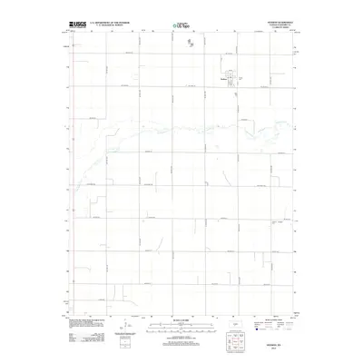
2012 Map of Hudson
USGS Topo · Published 2012About this map
The town of Hudson serves as the primary focal point of this Stafford County survey, situated along a grid of local roads including Main St and N Hudson Rd. The settlement’s core includes the local Post Office and the nearby Trinity Cem. The landscape is dominated by the winding course of Rattlesnake Cr, which meanders through the central and western portions of the quadrangle. In the southeastern corner, the small settlement of Bedford is noted near the Feldhut Cem, illustrating the dispersed nature of these agricultural communities. The terrain is organized by an extensive section-line road network, such as NE 100th St and NE 60th St, which connects isolated farmsteads and rural sites across this portion of central Kansas.
Find a feature on this map
27 named features on this map. Tap any name to fly to it.
Don’t see what you’re looking for? This feature index may not catch every label — zoom into the map to look around manually.
Map Details
Editions of this 2012 Hudson Map
This is the sole edition of this map. No revisions or reprints were ever made.
Other maps of this area

1891 · Great Bend
USGS Topo · 1:125,000

1892 · Pratt
USGS Topo · 1:125,000

1893 · Great Bend
USGS Topo · 1:125,000

1894 · Pratt
USGS Topo · 1:125,000

1955 · Great Bend
USGS Topo · 1:250,000

1955 · Pratt
USGS Topo · 1:250,000

1957 · Great Bend
USGS Topo · 1:250,000

1958 · Great Bend
USGS Topo · 1:250,000

1959 · Pratt
USGS Topo · 1:250,000
1970 · Hudson NW
USGS Topo · 1:24,000