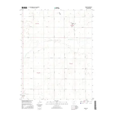
2015 Map of Hudson
USGS Topo · Published 2015About this map
Hudson serves as a focal point in this portion of Stafford County, where the street grid of Church St, Main St, and S View St defines the small town's footprint. The landscape is characterized by a high density of wetlands and the winding course of Rattlesnake Cr, which meanders through the central plains. This area is heavily subdivided by a rigid township and range system, reflected in the extensive network of section-line roads such as NE 110th St and NE 40th St. For those documenting family history, the presence of Trinity Cem near the town center and the more isolated Feldhut Cem to the southeast provides critical reference points. In the southwest corner, the edge of Saint John appears, marking the transition toward the county seat.
Find a feature on this map
29 named features on this map. Tap any name to fly to it.
Don’t see what you’re looking for? This feature index may not catch every label — zoom into the map to look around manually.
Map Details
Editions of this 2015 Hudson Map
This is the sole edition of this map. No revisions or reprints were ever made.
Other maps of this area

1891 · Great Bend
USGS Topo · 1:125,000

1892 · Pratt
USGS Topo · 1:125,000

1893 · Great Bend
USGS Topo · 1:125,000

1894 · Pratt
USGS Topo · 1:125,000

1955 · Great Bend
USGS Topo · 1:250,000

1955 · Pratt
USGS Topo · 1:250,000

1957 · Great Bend
USGS Topo · 1:250,000

1958 · Great Bend
USGS Topo · 1:250,000

1959 · Pratt
USGS Topo · 1:250,000
1970 · Hudson NW
USGS Topo · 1:24,000