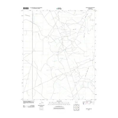
2010 Map of Hugh Lake
USGS Topo · Published 2010About this map
Hugh Lake sits as a central landmark in this high-desert landscape of the Eastern Navajo Agency, where seasonal watercourses define the layout of the land. The drainage system is dominated by the intricate branching of Gallegos Canyon and the West Fork Gallegos Canyon to the east, while Charlie Wash and Hugh Wash converge toward the center of the sheet. The network of local infrastructure is represented by roads such as Road 7100 and County Rd 7030, reflecting the rural transportation grid of San Juan County. Smaller features like Charlie Well suggest the vital importance of water management in this arid environment. The map provides a detailed view of the terrain's transition from the broad West Draw to the sharper incisions of Ojo Amarillo Canyon in the northwest corner, documenting the subtle elevations and drainage patterns of the region at the start of the 21st century.
Find a feature on this map
17 named features on this map. Tap any name to fly to it.
Don’t see what you’re looking for? This feature index may not catch every label — zoom into the map to look around manually.
Map Details
Editions of this 2010 Hugh Lake Map
This is the sole edition of this map. No revisions or reprints were ever made.
Other maps of this area

1889 · Chaco
USGS Topo · 1:250,000

1892 · Chaco
USGS Topo · 1:250,000

1927 · Sulphur Spring
USGS Topo · 1:96,000

1928 · Kirtland
USGS Topo · 1:125,000

1932 · Kirtland
USGS Topo · 1:125,000

1954 · Shiprock
USGS Topo · 1:250,000

1958 · Shiprock
USGS Topo · 1:250,000

1959 · Shiprock
USGS Topo · 1:250,000
1965 · Farmington South
USGS Topo · 1:24,000
1965 · Gallegos Trading Post
USGS Topo · 1:24,000