1944 Map of Hughesville
USGS Topo · Published 1944About this map
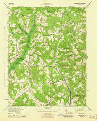
Zekiah Swamp dominates the western landscape of this mid-century Southern Maryland survey, creating a natural barrier between the settlements of Bryantown and Grosstown. During this period, the region maintained a rural, agrarian character defined by woodlots and scattered farmsteads, even as a U S Navy rail line cut through the eastern section near Hughesville. Local life was anchored by long-standing institutions like St Peters Ch in the north and Old Field Church near the intersection of Benedict Rd.
Find a feature on this map
49 named features on this map. Tap any name to fly to it.
Don’t see what you’re looking for? This feature index may not catch every label — zoom into the map to look around manually.
Map Details
Editions of this 1944 Hughesville Map
This is the sole edition of this map. No revisions or reprints were ever made.
Other maps of this area

1892 · Leonardtown
USGS Topo · 1:62,500

1892 · Prince Frederick
USGS Topo · 1:62,500

1892 · Brandywine
USGS Topo · 1:62,500

1894 · Wicomico
USGS Topo · 1:62,500

1895 · Prince Frederick
USGS Topo · 1:62,500

1895 · Wicomico
USGS Topo · 1:62,500

1895 · Brandywine
USGS Topo · 1:62,500

1895 · Leonardtown
USGS Topo · 1:62,500

1895 · Nomini
USGS Topo · 1:125,000

1898 · Nomini
USGS Topo · 1:125,000