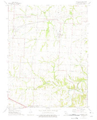
1973 Map of Hughesville
USGS Topo · Published 1975About this map
Hughesville and Dresden anchor this central Missouri landscape, which is defined by a dense network of agricultural property boundaries and watercourses during the early 1970s. The northern portion of the quadrangle is traversed by extensive Pipelines and a notable Pumping Station, signaling the modern industrial infrastructure overlaying the traditional farm plots. The drainage pattern is complex, with Heath Creek and Hess Creek cutting through the northern townships, while the southern reaches are shaped by Little Muddy Creek and Brushy Creek.
Find a feature on this map
24 named features on this map. Tap any name to fly to it.
Don’t see what you’re looking for? This feature index may not catch every label — zoom into the map to look around manually.
Map Details
Editions of this 1973 Hughesville Map
This is the sole edition of this map. No revisions or reprints were ever made.
Other maps of this area

1887 · Sedalia
USGS Topo · 1:125,000

1894 · Sedalia
USGS Topo · 1:125,000

1939 · Sweet Springs
USGS Topo · 1:62,500

1940 · Sweet Springs
USGS Topo · 1:62,500

1941 · Sweet Springs
USGS Topo · 1:62,500

1944 · Sedalia West
USGS Topo · 1:24,000

1944 · Sedalia East
USGS Topo · 1:24,000

1945 · Sweet Springs
USGS Topo · 1:62,500

1946 · Sedalia West
USGS Topo · 1:24,000

1946 · Sedalia East
USGS Topo · 1:24,000