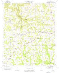
1949 Map of Hulaco
USGS Topo · Published 1976About this map
The Tennessee Valley Divide snakes through this 1949 survey, marking a significant hydrologic boundary where the topography shifts from the headwaters of Wolf Creek and Berry Creek toward the northern drainages. This high ground is populated by a network of rural communities and church-centered settlements, including Joppa, Hulaco, and Ryan Crossroads. The map highlights the social fabric of the era through numerous rural institutions such as Ruth Sch and Hulaco Sch, alongside congregational hubs like Mt Hermon Church and Pleasant Ridge Church.
Find a feature on this map
52 named features on this map. Tap any name to fly to it.
Don’t see what you’re looking for? This feature index may not catch every label — zoom into the map to look around manually.
Map Details
Editions of this 1949 Hulaco Map
This is the sole edition of this map. No revisions or reprints were ever made.
Other maps of this area

1885 · Gadsden
USGS Topo · 1:125,000

1888 · Cullman
USGS Topo · 1:125,000

1888 · Gadsden
USGS Topo · 1:125,000

1892 · Cullman
USGS Topo · 1:125,000

1892 · Gadsden
USGS Topo · 1:125,000

1895 · Gadsden
USGS Topo · 1:125,000

1903 · Gadsden
USGS Topo · 1:125,000

1936 · Guntersville Dam
USGS Topo · 1:24,000

1936 · Hulaco
USGS Topo · 1:24,000

1936 · Arab
USGS Topo · 1:24,000