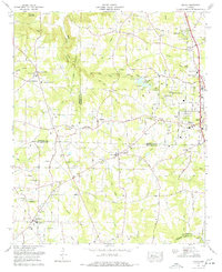
1976 Map of Hulaco
USGS Topo · Published 1977About this map
The Tennessee Valley Divide snakes through this portion of North Alabama, separating the northern waters of Cotaco Creek from the southern drainages that feed the Mulberry Fork. This mid-1970s landscape shows the transition from rural crossroads like Hulaco and Ryan Crossroads to the growing suburban expansion of Arab. Local history and genealogy are well-preserved through numerous landmark churches and burial sites, including the Ryan Memorial Gardens and Crawford Cem. Near the community of Meadowood, a Drive-in theater sits along the Huntsville Road, reflecting the recreational culture of the era. The terrain is marked by significant elevations like Cameron Mountain and Section Hollow, while smaller communities such as Joppa and Baileyton anchor the southern reaches of the map along Beckworth Creek.
Find a feature on this map
77 named features on this map. Tap any name to fly to it.
Don’t see what you’re looking for? This feature index may not catch every label — zoom into the map to look around manually.
Map Details
Editions of this 1976 Hulaco Map
This is the sole edition of this map. No revisions or reprints were ever made.
Other maps of this area

1885 · Gadsden
USGS Topo · 1:125,000

1888 · Cullman
USGS Topo · 1:125,000

1888 · Gadsden
USGS Topo · 1:125,000

1892 · Cullman
USGS Topo · 1:125,000

1892 · Gadsden
USGS Topo · 1:125,000

1895 · Gadsden
USGS Topo · 1:125,000

1903 · Gadsden
USGS Topo · 1:125,000

1936 · Guntersville Dam
USGS Topo · 1:24,000

1936 · Hulaco
USGS Topo · 1:24,000

1936 · Arab
USGS Topo · 1:24,000