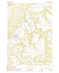
1984 Map of Hulett
USGS Topo · Published 1985About this map
The Belle Fourche River snakes through this corner of northeastern Wyoming, carving a deep valley that defines the local landscape around the town of Hulett. During the early 1980s, the community's footprint remained concentrated along the riverbanks, supported by infrastructure like the Sewage Disposal Plant and nearby highway routes 24 and 112. The surrounding terrain is a complex network of drainage basins and high ground, where watercourses like Sourdough Creek and Moore Creek feed into the primary river system.
Find a feature on this map
20 named features on this map. Tap any name to fly to it.
Don’t see what you’re looking for? This feature index may not catch every label — zoom into the map to look around manually.
Map Details
Editions of this 1984 Hulett Map
This is the sole edition of this map. No revisions or reprints were ever made.
Other maps of this area

1901 · Aladdin
USGS Topo · 1:125,000

1903 · Aladdin
USGS Topo · 1:125,000

1905 · Devils Tower
USGS Topo · 1:125,000

1954 · Strawberry Hill
USGS Topo · 1:24,000

1954 · Storm Hill
USGS Topo · 1:24,000

1954 · Gillette
USGS Topo · 1:250,000

1955 · Devils Tower
USGS Topo · 1:62,500

1955 · Gillette
USGS Topo · 1:250,000

1957 · Mona
USGS Topo · 1:62,500

1957 · Seely
USGS Topo · 1:62,500