
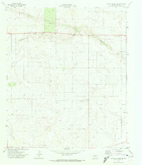
1970 Map of Humble City SE
USGS Topo · Published 1980About this map
The arid borderlands of the Llano Estacado define this landscape along the state line of New Mexico Texas. This area, surveyed in the late 1960s and updated via aerial photography in 1979, is characterized by a high concentration of energy infrastructure across the Lea and Gaines County line. The terrain is marked by ephemeral watercourses, primarily Johnson Draw and Seminole Draw, which cut through a landscape densely dotted with oil wells and interconnected pipelines. Aside from the industrial footprint and a few industrial landmarks like a Radio Tower and Gravel Pit, the map reveals a sparsely settled region dominated by the large-scale extraction economy that reshaped the Permian Basin during the mid-twentieth century.
Find a feature on this map
6 named features on this map. Tap any name to fly to it.
Don’t see what you’re looking for? This feature index may not catch every label — zoom into the map to look around manually.
Map Details
Editions of this 1970 Humble City SE Map
This is the sole edition of this map. No revisions or reprints were ever made.
Other maps of this area

1954 · Hobbs
USGS Topo · 1:250,000

1958 · Hobbs
USGS Topo · 1:250,000

1969 · Humble City
USGS Topo · 1:24,000

1969 · Hobbs East
USGS Topo · 1:24,000

1969 · Humble City NE
USGS Topo · 1:24,000

1969 · Hobbs West
USGS Topo · 1:24,000

1969 · Humble City SE
USGS Topo · 1:24,000

1971 · Higginbotham
USGS Topo · 1:24,000

1971 · Denver City SW
USGS Topo · 1:24,000
1971 · Paynes Corner NW
USGS Topo · 1:24,000