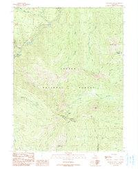
1991 Map of Humboldt Peak
USGS Topo · Published 1991About this map
Humboldt Peak and Humboldt Summit dominate this high-elevation landscape within the Lassen National Forest, marking a rugged intersection where Tehama, Plumas, and Butte counties meet. The area is defined by a dense network of watercourses, including the westward-flowing Deer Creek and the southern drainage of Butt Creek. This 1991 provisional study documents several historic and modern transportation corridors, most notably the Lassen Trail and the Pacific Crest National Scenic Trail, alongside the Humboldt Road. The terrain is characterized by prominent landmarks such as Robbers Roost and the rocky outcrops of Eagle Rocks. Much of the western portion of the sheet is protected under the State Game Refuge 1-G, illustrating the region's long-standing status as a conservation and wilderness area at the end of the twentieth century.
Find a feature on this map
32 named features on this map. Tap any name to fly to it.
Don’t see what you’re looking for? This feature index may not catch every label — zoom into the map to look around manually.
Map Details
Editions of this 1991 Humboldt Peak Map
This is the sole edition of this map. No revisions or reprints were ever made.
Other maps of this area

1886 · Lassen Peak
USGS Topo · 1:250,000

1892 · Lassen Peak
USGS Topo · 1:250,000

1894 · Lassen Peak
USGS Topo · 1:250,000

1935 · Paynes Creek
USGS Topo · 1:96,000

1941 · Mineral
USGS Topo · 1:125,000

1955 · Westwood
USGS Topo · 1:250,000

1956 · Lassen Peak
USGS Topo · 1:62,500

1956 · Mt. Harkness
USGS Topo · 1:62,500

1958 · Westwood
USGS Topo · 1:250,000

1958 · Jonesville
USGS Topo · 1:62,500