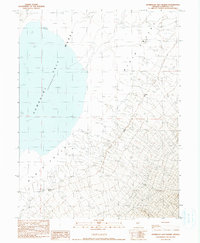
1990 Map of Humboldt Salt Marsh
USGS Topo · Published 1990About this map
Humboldt Salt Marsh (Depression) dominates the floor of Dixie Valley in this late-twentieth-century study of the Churchill County basin. The landscape is defined by the ephemeral nature of water in a high-desert environment, where expansive Alkali Flat areas are punctuated by small, vital hydrologic features. Human activity and livestock management are evidenced by the presence of the Dye-Elias Well and a Flowing Well, alongside more natural sources such as Buckbrush Spring. Access through this remote terrain is limited to 4wd tracks that navigate the wash-cut slopes and the edges of the marsh depression, illustrating the area's isolation and its reliance on scattered groundwater sources for any functional use.
Find a feature on this map
10 named features on this map. Tap any name to fly to it.
Don’t see what you’re looking for? This feature index may not catch every label — zoom into the map to look around manually.
Map Details
Editions of this 1990 Humboldt Salt Marsh Map
This is the sole edition of this map. No revisions or reprints were ever made.
Other maps of this area

1908 · Carson Sink
USGS Topo · 1:250,000

1910 · Carson Sink
USGS Topo · 1:250,000

1955 · Millett
USGS Topo · 1:250,000

1957 · Reno
USGS Topo · 1:250,000

1959 · Reno
USGS Topo · 1:250,000

1959 · Millett
USGS Topo · 1:250,000

1960 · Reno
USGS Topo · 1:250,000

1966 · Clan Alpine Ranch
USGS Topo · 1:62,500

1966 · Humboldt Salt Marsh
USGS Topo · 1:62,500

1966 · Dixie Hot Springs
USGS Topo · 1:62,500