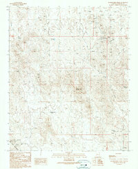
1990 Map of Hummingbird Spring
USGS Topo · Published 1990About this map
Moon Anchor Mine and the US Mine anchor the industrial character of this desert landscape, where mining activity is recorded through dozens of prospect pits and mine shafts scattered throughout the territory. The terrain is defined by prominent elevations such as Sugarloaf Mountain, Big Horn Peak, and Black Butte, while human infrastructure is limited to rugged tracks like Old Camp Road and Woodchopper Road. Resource management in this arid environment is evident through labels like Dead Horse Tank, Wildcat Well, and the namesake Hummingbird Spring. This 1990 provisional update, based on earlier surveys and field checks from 1986, captures a specific era of mineral exploration and land use in western Maricopa County, showing the network of washes like Coyote Wash and Dead Horse Wash that dictate the natural flow of the land.
Find a feature on this map
27 named features on this map. Tap any name to fly to it.
Don’t see what you’re looking for? This feature index may not catch every label — zoom into the map to look around manually.
Map Details
Editions of this 1990 Hummingbird Spring Map
This is the sole edition of this map. No revisions or reprints were ever made.
Other maps of this area

1942 · Vicksburg
USGS Topo · 1:250,000

1954 · Phoenix
USGS Topo · 1:250,000

1957 · Phoenix
USGS Topo · 1:250,000

1958 · Phoenix
USGS Topo · 1:250,000

1960 · Phoenix
USGS Topo · 1:250,000

1961 · Vulture Mountains
USGS Topo · 1:62,500

1961 · Big Horn Mts
USGS Topo · 1:62,500

1962 · Belmont Mts
USGS Topo · 1:62,500
1962 · Aguila
USGS Topo · 1:62,500

1969 · Phoenix
USGS Topo · 1:250,000