1994 Map of Hungry Horse
USGS Topo · Published 1997About this map
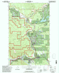
Hungry Horse and Martin City anchor the southern gateway to the spectacular river systems of northwest Montana in this mid-1990s record. The map details the confluence of the Middle Fork Flathead River and the South Fork Flathead River, showing how these waters shape the boundaries of Glacier National Park and the Flathead National Forest. The presence of the Burlington Northern railroad corridor, winding through Badrock Canyon, underscores the historical and logistical importance of this mountain passage.
Find a feature on this map
29 named features on this map. Tap any name to fly to it.
Don’t see what you’re looking for? This feature index may not catch every label — zoom into the map to look around manually.
Map Details
Editions of this 1994 Hungry Horse Map
This is the sole edition of this map. No revisions or reprints were ever made.
Other maps of this area

1904 · Chief Mountain
USGS Topo · 1:125,000

1906 · Kintla Lakes
USGS Topo · 1:125,000

1914 · Nyack
USGS Topo · 1:125,000

1938 · Chief Mountain
USGS Topo · 1:125,000

1938 · Kintla Lakes
USGS Topo · 1:125,000

1943 · Kalispell
USGS Topo · 1:125,000

1957 · Kalispell
USGS Topo · 1:250,000

1960 · Kalispell
USGS Topo · 1:250,000

1960 · Cut Bank
USGS Topo · 1:250,000

1961 · Kalispell
USGS Topo · 1:250,000