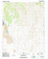
1992 Map of Hurley East
USGS Topo · Published 1992About this map
The industrial footprint of southwestern New Mexico is clearly visible on the eastern edge of Hurley in the early 1990s. The landscape is dominated by massive Tailings Ponds and a Tailings Pond that underscore the scale of regional mining operations. Beyond the corporate boundary and the residential blocks of the town, the terrain rises into the foothills, where numerous watercourses like Whitewater Creek and Lampbright Draw carve through the high desert. Scattered across the hills are isolated corrals and a Radio Facility, while Black Hill stands as a prominent landmark north of the town center. The presence of Athletic Fields near the town core provides a view of the community life that existed alongside the heavy industry of the copper-rich region. Significant canyons, including Rustler Canyon and Oak Canyon, suggest a complex drainage system across the eastern portion of the survey.
Find a feature on this map
17 named features on this map. Tap any name to fly to it.
Don’t see what you’re looking for? This feature index may not catch every label — zoom into the map to look around manually.
Map Details
Editions of this 1992 Hurley East Map
This is the sole edition of this map. No revisions or reprints were ever made.
Other maps of this area

1909 · Silver City
USGS Topo · 1:125,000

1937 · Santa Rita
USGS Topo · 1:24,000

1947 · Faywood Station
USGS Topo · 1:24,000

1947 · Fort Bayard
USGS Topo · 1:24,000

1948 · Santa Rita
USGS Topo · 1:24,000

1948 · Hurley East
USGS Topo · 1:24,000

1949 · Fort Bayard
USGS Topo · 1:24,000

1949 · Whitewater
USGS Topo · 1:24,000

1949 · Hurley East
USGS Topo · 1:24,000

1949 · Faywood Station
USGS Topo · 1:24,000