
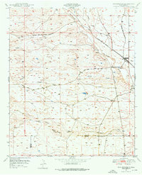
1949 Map of Whitewater
USGS Topo · Published 1949About this map
Whitewater serves as the primary rail hub on this southwest New Mexico landscape, situated at a junction where the Atchison Topeka and Santa Fe railroad meets an older, abandoned rail grade. This transition in infrastructure highlights a shifting economic pattern in the high desert at the end of the 1940s. The terrain is defined by complex drainage systems, including the San Vicente Arroyo and Hogback Draw, which flow around the prominent Hogback Mountain. The map also captures the local transit network via the White Signal Road and several smaller watercourses like Oak Grove Creek and Cherry Creek. Notable landmarks for water management in this arid environment include a Water Tank near the tracks and a Dam located along a tributary of White Cherry Creek, illustrating the critical role of water for both the railroad and the local landscape.
Find a feature on this map
16 named features on this map. Tap any name to fly to it.
Don’t see what you’re looking for? This feature index may not catch every label — zoom into the map to look around manually.
Map Details
Editions of this 1949 Whitewater Map
2 editions found
Other maps of this area

1909 · Silver City
USGS Topo · 1:125,000

1947 · Faywood Station
USGS Topo · 1:24,000

1948 · Hurley East
USGS Topo · 1:24,000

1949 · Hurley East
USGS Topo · 1:24,000

1949 · Faywood Station
USGS Topo · 1:24,000

1949 · Hurley West
USGS Topo · 1:24,000

1950 · Tyrone
USGS Topo · 1:24,000

1950 · White Signal
USGS Topo · 1:24,000

1951 · White Signal
USGS Topo · 1:24,000
1951 · Tyrone
USGS Topo · 1:24,000