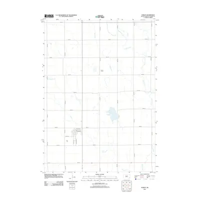
2012 Map of Hurley
USGS Topo · Published 2012About this map
Hurley Cr and the meandering Vermillion River define the agricultural landscape of Turner County in this early 21st-century survey. The town of Hurley is detailed with its residential grid, including Center Ave and Park Blvd, alongside the Hurley Cem located just south of the main settlement. The surrounding prairie is marked by a strict section-line road network, including 280th St and 457th Ave, which connect isolated rural points of interest like the Dangel Airport. Water management is evident through features such as the Alberty Ditch, while natural catchment areas like Mud Lake remain prominent landmarks amidst the cultivated fields. This topographic record illustrates the persistent rural character and water drainage patterns of the southeastern South Dakota plains.
Find a feature on this map
28 named features on this map. Tap any name to fly to it.
Don’t see what you’re looking for? This feature index may not catch every label — zoom into the map to look around manually.
Map Details
Editions of this 2012 Hurley Map
This is the sole edition of this map. No revisions or reprints were ever made.
Other maps of this area

1897 · Canton
USGS Topo · 1:125,000

1898 · Parker
USGS Topo · 1:125,000

1900 · Canton
USGS Topo · 1:125,000

1955 · Sioux Falls
USGS Topo · 1:250,000

1958 · Sioux Falls
USGS Topo · 1:250,000

1962 · Lennox NW
USGS Topo · 1:24,000

1964 · Lennox
USGS Topo · 1:24,000
1968 · Beresford NW
USGS Topo · 1:24,000
1968 · Parker NE
USGS Topo · 1:24,000
1968 · Hurley
USGS Topo · 1:24,000