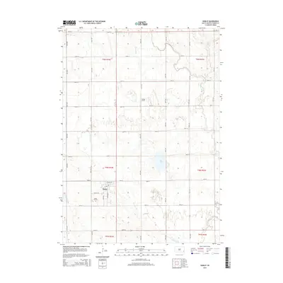
2015 Map of Hurley
USGS Topo · Published 2015About this map
The town of Hurley serves as the central hub of this agricultural landscape in Turner County, defined by a grid of rural routes like 457th Ave and 280th St. Local history is centered around the village plat, where Illinois Ave and Washington St meet, and the nearby Hurley Cemetery to the south. Water management and drainage are prominent features of the terrain, visible in the winding course of the Vermillion River and the artificial Alberty Ditch. The presence of Dangel Airport north of town and Mud Lake to the east highlights the mix of private utility and natural marshy lowlands that characterize this portion of the eastern South Dakota plains.
Find a feature on this map
33 named features on this map. Tap any name to fly to it.
Don’t see what you’re looking for? This feature index may not catch every label — zoom into the map to look around manually.
Map Details
Editions of this 2015 Hurley Map
This is the sole edition of this map. No revisions or reprints were ever made.
Other maps of this area

1897 · Canton
USGS Topo · 1:125,000

1898 · Parker
USGS Topo · 1:125,000

1900 · Canton
USGS Topo · 1:125,000

1955 · Sioux Falls
USGS Topo · 1:250,000

1958 · Sioux Falls
USGS Topo · 1:250,000

1962 · Lennox NW
USGS Topo · 1:24,000

1964 · Lennox
USGS Topo · 1:24,000
1968 · Beresford NW
USGS Topo · 1:24,000
1968 · Parker NE
USGS Topo · 1:24,000
1968 · Hurley
USGS Topo · 1:24,000