
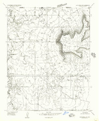
1954 Map of Hurricane Cliffs 2 NE
USGS Topo · Published 1956About this map
Hurricane Cliffs dominate the landscape in this mid-century topographic study of the Arizona-Utah border region. The dramatic escarpment separates the high plateaus from the lower desert drainages, creating a complex network of canyons and seasonal washes. Water sources, vital for survival in this arid environment, are clearly marked and include isolated points like Sand Spring, Peach Spring, and a simple Seep. The drainage patterns are defined by the Fort Pearce Wash and Main Run, which cut through the terrain toward the northwest. This 1954 mapping effort captures the area before modern infrastructure arrived, showing only unimproved roads and cattle tanks scattered across the border between Washington and Mohave County. The deep incisions of Rock Canyon and Cottonwood Canyon illustrate the geological forces that shaped this remote corner of the American Southwest.
Find a feature on this map
15 named features on this map. Tap any name to fly to it.
Don’t see what you’re looking for? This feature index may not catch every label — zoom into the map to look around manually.
Map Details
Editions of this 1954 Hurricane Cliffs 2 NE Map
This is the sole edition of this map. No revisions or reprints were ever made.
Other maps of this area

1885 · St. George
USGS Topo · 1:250,000

1886 · Mt. Trumbull
USGS Topo · 1:250,000

1891 · St. George
USGS Topo · 1:250,000

1892 · Mt. Trumbull
USGS Topo · 1:250,000

1953 · Cedar City
USGS Topo · 1:250,000

1953 · Grand Canyon
USGS Topo · 1:250,000

1954 · La Verkin 4 SW
USGS Topo · 1:24,000

1954 · Hurricane Cliffs 2 NW
USGS Topo · 1:24,000

1954 · La Verkin 3 SE
USGS Topo · 1:24,000
1954 · Lost Spring NW
USGS Topo · 1:24,000