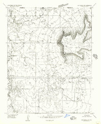
1954 Map of Lost Spring NW
USGS Topo · Published 1956About this map
Lost Spring Mountain dominates the eastern horizon of this 1954 survey, its steep escarpments overlooking the arid basin of the Arizona Strip. This preliminary topographic record traces a landscape defined by water scarcity and early resource exploration along the border of Washington and Mohave counties. Numerous vital water points are identified, including Cottonwood Spring, Lytle Spring, and Antelope Spring, which likely served as crucial stops for ranchers and travelers in this remote high-desert environment.
Find a feature on this map
16 named features on this map. Tap any name to fly to it.
Don’t see what you’re looking for? This feature index may not catch every label — zoom into the map to look around manually.
Map Details
Editions of this 1954 Lost Spring NW Map
This is the sole edition of this map. No revisions or reprints were ever made.
Other maps of this area

1885 · St. George
USGS Topo · 1:250,000

1886 · Mt. Trumbull
USGS Topo · 1:250,000

1891 · St. George
USGS Topo · 1:250,000

1892 · Mt. Trumbull
USGS Topo · 1:250,000

1953 · Cedar City
USGS Topo · 1:250,000

1953 · Grand Canyon
USGS Topo · 1:250,000

1954 · La Verkin 4 SE
USGS Topo · 1:24,000

1954 · La Verkin 4 SW
USGS Topo · 1:24,000

1954 · Lost Spring SE
USGS Topo · 1:24,000

1954 · Hurricane Cliffs 2 NE
USGS Topo · 1:24,000