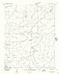
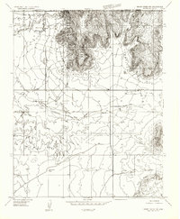
1954 Map of Lost Spring SE
USGS Topo · Published 1956About this map
Upper Clayhole Valley defines the southern portion of this mid-century topographic record of Mohave County, where the desert landscape is shaped by seasonal drainages and livestock infrastructure. The route of the Navajo Trail cuts across the western section, representing a historic path through this arid basin. Water management is the primary sign of human activity, evidenced by the Flattop Reservoir and various water catchments designated as Tank or Tanks across the northern flats.
Find a feature on this map
11 named features on this map. Tap any name to fly to it.
Don’t see what you’re looking for? This feature index may not catch every label — zoom into the map to look around manually.
Map Details
Editions of this 1954 Lost Spring SE Map
This is the sole edition of this map. No revisions or reprints were ever made.
Other maps of this area

1886 · Mt. Trumbull
USGS Topo · 1:250,000

1886 · Kaibab
USGS Topo · 1:250,000

1892 · Mt. Trumbull
USGS Topo · 1:250,000

1953 · Grand Canyon
USGS Topo · 1:250,000
1954 · Heaton Knolls NW
USGS Topo · 1:24,000
1954 · Short Creek SW
USGS Topo · 1:24,000
1954 · Lost Spring NW
USGS Topo · 1:24,000
1954 · Short Creek NW
USGS Topo · 1:24,000
1954 · Lost Spring Mtn
USGS Topo · 1:62,500
1954 · Short Creek
USGS Topo · 1:62,500