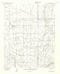
1954 Map of Short Creek SW
USGS Topo · Published 1956About this map
Yellowstone Mesa and Cedar Ridge dominate this mid-century high-desert landscape in Mohave County, where life followed the sparse availability of water. The map records a network of vital watering points essential for ranching, including Brinkerhoff Well, Daves Well, and Fern Tank. Human activity is centered around the Esplins Corral and scattered ranching infrastructure like the Windmill near Cedar Ridge. This preliminary edition, based on 1953 aerial photography, captures the era's land use through a system of unimproved roads and trails connecting isolated landmarks such as Gudger Well and Jenson Well. The terrain transitions from the heights of the mesa down into Upper Clay Hole Valley, defined by the erosive path of the Big Sand Wash.
Find a feature on this map
15 named features on this map. Tap any name to fly to it.
Don’t see what you’re looking for? This feature index may not catch every label — zoom into the map to look around manually.
Map Details
Editions of this 1954 Short Creek SW Map
This is the sole edition of this map. No revisions or reprints were ever made.
Other maps of this area

1886 · Mt. Trumbull
USGS Topo · 1:250,000

1886 · Kaibab
USGS Topo · 1:250,000

1892 · Mt. Trumbull
USGS Topo · 1:250,000

1953 · Grand Canyon
USGS Topo · 1:250,000

1954 · Heaton Knolls NW
USGS Topo · 1:24,000

1954 · Lost Spring SE
USGS Topo · 1:24,000

1954 · Short Creek SE
USGS Topo · 1:24,000
1954 · Short Creek NW
USGS Topo · 1:24,000
1954 · Lost Spring Mtn
USGS Topo · 1:62,500

1954 · Short Creek
USGS Topo · 1:62,500