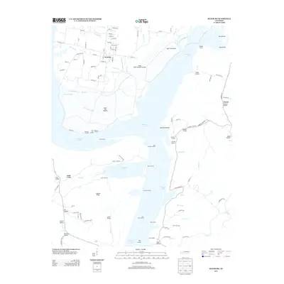
2013 Map of Hustburg
USGS Topo · Published 2013About this map
Kentucky Lake dominates this landscape along the Tennessee River, where the water has reshaped the local topography and commerce. In the northern reaches, the community of Hustburg sits adjacent to the Duck River Dewatering Area, a managed landscape that borders the fertile Upper Big Bottom and Lower Big Bottom. This survey documents a river-centered economy that persists through numerous historic access points, including Sycamore Landing, Cuba Landing, and Lees Point Landing. These landings, along with family-named terrain features like Swader Hollow and Carroll Hollow, provide essential geographic markers for those tracing the history of local river travel and settlement. Further south, the map details the terrain around Sinkhole Ridge and the small residential pockets of Maple Acres and Strawberry Gables, illustrating how the region has transitioned from traditional bottomland farming toward contemporary rural residential life.
Find a feature on this map
114 named features on this map. Tap any name to fly to it.
Don’t see what you’re looking for? This feature index may not catch every label — zoom into the map to look around manually.
Map Details
Editions of this 2013 Hustburg Map
This is the sole edition of this map. No revisions or reprints were ever made.
Other maps of this area

1936 · Hurricane Mills
USGS Topo · 1:24,000

1936 · Camden
USGS Topo · 1:24,000

1936 · Daniels Landing
USGS Topo · 1:24,000

1936 · Johnsonville
USGS Topo · 1:24,000

1936 · Sugar Tree
USGS Topo · 1:24,000

1936 · Lobelville
USGS Topo · 1:24,000

1936 · Rockport
USGS Topo · 1:24,000

1936 · Waverly
USGS Topo · 1:24,000

1936 · Hustburg
USGS Topo · 1:24,000

1949 · Daniels Landing
USGS Topo · 1:24,000