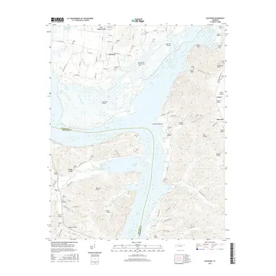
2016 Map of Hustburg
USGS Topo · Published 2016About this map
Kentucky Lake and the meandering course of the Tennessee River dominate this landscape on the border of Humphreys and Benton counties. The modern town of New Johnsonville sits at the northern edge, while the older settlement of Hustburg anchors the central agricultural plains. The eastern terrain is defined by a dense network of hollows and bottoms, including Swader Hollow and Sycamore Bottom, which descend toward the river. This 2016 survey illustrates the heavy management of the local watershed, prominently featuring the Duck River Dewatering Area and the industrial Foote-Mineral Company Tailings Pond. Genealogists will find a significant concentration of family burial grounds scattered throughout the ridges and valleys, such as DePriest Cem, Crockett Cem, and Eagle Creek Cem, providing a clear record of long-established local lineages in the rural countryside around Bakerville.
Find a feature on this map
111 named features on this map. Tap any name to fly to it.
Don’t see what you’re looking for? This feature index may not catch every label — zoom into the map to look around manually.
Map Details
Editions of this 2016 Hustburg Map
This is the sole edition of this map. No revisions or reprints were ever made.
Other maps of this area

1936 · Hurricane Mills
USGS Topo · 1:24,000

1936 · Camden
USGS Topo · 1:24,000

1936 · Daniels Landing
USGS Topo · 1:24,000

1936 · Johnsonville
USGS Topo · 1:24,000

1936 · Sugar Tree
USGS Topo · 1:24,000

1936 · Lobelville
USGS Topo · 1:24,000

1936 · Rockport
USGS Topo · 1:24,000

1936 · Waverly
USGS Topo · 1:24,000

1936 · Hustburg
USGS Topo · 1:24,000

1949 · Daniels Landing
USGS Topo · 1:24,000