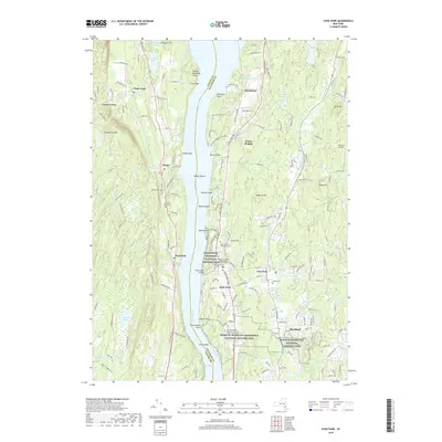
2019 Map of Hyde Park
USGS Topo · Published 2019About this map
Presidential legacies and Gilded Age estates define this stretch of the Hudson River Valley. The shoreline is punctuated by significant landmarks, most notably the Home of Franklin D Roosevelt National Historic Site and the nearby Eleanor Roosevelt National Historic Site, which anchor the southern end of the map. Further north, the Vanderbilt Mansion National Historic Site sits prominently above the river near Hyde Park. Across the water in Ulster County, the landscape transitions to the wooded heights of Shaupeneak Mtn and the agricultural surroundings of Ulster Park. Several historic burial grounds, including the Saint James Episcopal Cem and Hyde Park Dutch Reformed Church Cem, offer essential reference points for local genealogists tracing families in the riverfront communities of Staatsburg and Esopus.
Find a feature on this map
177 named features on this map. Tap any name to fly to it.
Don’t see what you’re looking for? This feature index may not catch every label — zoom into the map to look around manually.
Map Details
Editions of this 2019 Hyde Park Map
This is the sole edition of this map. No revisions or reprints were ever made.
Other maps of this area

1893 · Poughkeepsie
USGS Topo · 1:62,500

1894 · Poughkeepsie
USGS Topo · 1:62,500

1898 · Rhinebeck
USGS Topo · 1:62,500

1901 · Rosendale
USGS Topo · 1:62,500

1903 · Poughkeepsie
USGS Topo · 1:62,500

1903 · Newburg
USGS Topo · 1:62,500

1903 · Rosendale
USGS Topo · 1:62,500

1934 · Rhinebeck
USGS Topo · 1:48,000

1936 · Poughkeepsie
USGS Topo · 1:48,000

1939 · Rhinebeck
USGS Topo · 1:62,500