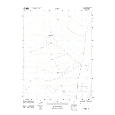
2011 Map of I X L Canyon
USGS Topo · Published 2011About this map
Silver Hill stands as a prominent landmark in this Nevada landscape, where the high desert terrain is carved by a complex network of drainage systems. The map illustrates a series of alluvial fans and deep cuts including Rock Creek Canyon, Alameda Canyon, and the central I X L Canyon. These features converge toward the broad basin of the Dixie Valley Wash in the east. Water sources are critical points in this arid environment, marked by sites such as Buck Brush Spring, Box Canyon Spring, and Mud or Willow Spring. The road network is sparse, centered on the primary thoroughfare of Dixie Valley Rd and the localized Cattle Rd, reflecting a landscape dedicated to ranching and passage through the remote Churchill County interior.
Find a feature on this map
22 named features on this map. Tap any name to fly to it.
Don’t see what you’re looking for? This feature index may not catch every label — zoom into the map to look around manually.
Map Details
Editions of this 2011 I X L Canyon Map
This is the sole edition of this map. No revisions or reprints were ever made.
Other maps of this area

1908 · Carson Sink
USGS Topo · 1:250,000

1910 · Carson Sink
USGS Topo · 1:250,000

1957 · Reno
USGS Topo · 1:250,000

1959 · Reno
USGS Topo · 1:250,000

1960 · Reno
USGS Topo · 1:250,000

1966 · Dixie Hot Springs
USGS Topo · 1:62,500

1969 · Cox Canyon
USGS Topo · 1:24,000

1969 · Table Mtn
USGS Topo · 1:24,000
1969 · Lone Rock SE
USGS Topo · 1:24,000
1972 · I X L Canyon
USGS Topo · 1:24,000