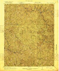
1916 Map of Iaeger
USGS Topo · Published 1916About this map
Iaeger stands as a central hub in the coal-country borderlands of southern West Virginia, situated at the confluence where the Tug Fork meets the branching creeks of the Sandy River district. This 1916 survey captures the region during a period of industrial transition, where the Norfolk and Western RR cuts through steep valleys to service small settlements like Wilmore and Ritter. The topography is defined by its extreme density of named branches and ridges, illustrating the reliance on narrow creek bottoms for transportation and habitation. Rural life is anchored by a network of local institutions, including the Joshua Day School and Cowpen School, alongside vital mail stops such as Avondale PO and Bradshaw PO. The map clearly delineates the zigzagging border between McDowell Co, West Virginia, and Buchanan Co, Virginia, tracing the high points of Height Ridge and Horse Ridge.
Find a feature on this map
72 named features on this map. Tap any name to fly to it.
Don’t see what you’re looking for? This feature index may not catch every label — zoom into the map to look around manually.
Map Details
Editions of this 1916 Iaeger Map
This is the sole edition of this map. No revisions or reprints were ever made.
Other maps of this area

1886 · Grundy
USGS Topo · 1:125,000

1887 · Warfield
USGS Topo · 1:125,000

1890 · Grundy
USGS Topo · 1:125,000

1891 · Tazewell
USGS Topo · 1:125,000

1891 · Oceana
USGS Topo · 1:125,000

1891 · Warfield
USGS Topo · 1:125,000

1892 · Grundy
USGS Topo · 1:125,000

1893 · Oceana
USGS Topo · 1:125,000

1895 · Tazewell
USGS Topo · 1:125,000

1897 · Tazewell
USGS Topo · 1:125,000