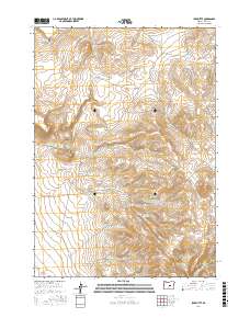
2017 Map of Ibex Butte
USGS Topo · Published 2017About this map
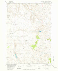
Ibex Butte and Ann Butte dominate this section of the high desert in Crook County, where the landscape is defined by its scarce but essential water resources. This 2017 survey reveals a system of artificial water management designed to support cattle ranching in an arid environment, characterized by a series of numbered catchments including Twelvemile Reservoir Number One, Twelvemile Reservoir Number Two, and Twelvemile Reservoir Number Three. These named reservoirs, alongside features like Santry Waterhole and Mills Waterhole, indicate the critical role of the Bureau of Land Management (BLM) and local ranchers in maintaining life across the sagebrush-covered hills. Sparse transportation routes, such as S Buck Creek Rd, provide the only access through this terrain, connecting isolated peaks like Kid Peak and the long elevation of Willow Ridge.
Find a feature on this map
25 named features on this map. Tap any name to fly to it.
Don’t see what you’re looking for? This feature index may not catch every label — zoom into the map to look around manually.
Map Details
Editions of this 2017 Ibex Butte Map
This is the sole edition of this map. No revisions or reprints were ever made.
Other maps of this area

1955 · Crescent
USGS Topo · 1:250,000

1955 · Burns
USGS Topo · 1:250,000

1957 · Crescent
USGS Topo · 1:250,000

1958 · Crescent
USGS Topo · 1:250,000

1958 · Burns
USGS Topo · 1:250,000

1959 · Burns
USGS Topo · 1:250,000
1970 · Crescent
USGS Topo · 1:250,000
1981 · Mackey Butte
USGS Topo · 1:24,000
1981 · Hardin Ranch
USGS Topo · 1:24,000
1981 · Twelvemile Reservoir
USGS Topo · 1:24,000