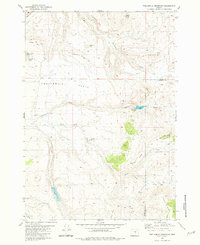
1981 Map of Twelvemile Reservoir
USGS Topo · Published 1981About this map
Twelvemile Table dominates this high-plateau landscape along the border of Crook Co and Harney Co as it appeared in the early 1980s. The map illustrates a region where water management was critical for ranching, evidenced by the scattered network of named water sources like Twelvemile Reservoir, Lillard Reservoir, and Coffee Lake, alongside seasonal features such as Old Lakebed Waterhole. Prominent geological formations including Grindstone Rim and Duck Ridge define the vertical relief of the area, while isolated peaks like Spike Butte and Speckle Butte serve as distinct landmarks across the rangeland. Human activity is largely represented by the Berger Ranch, situated near the confluence of Black Snag Creek and other small drainages. The abundance of named springs, such as Mayme Spring, indicates the essential points of interest for local land use and hydrology in this high-desert environment.
Find a feature on this map
27 named features on this map. Tap any name to fly to it.
Don’t see what you’re looking for? This feature index may not catch every label — zoom into the map to look around manually.
Map Details
Editions of this 1981 Twelvemile Reservoir Map
This is the sole edition of this map. No revisions or reprints were ever made.
Other maps of this area

1932 · Dayville
USGS Topo · 1:125,000

1936 · Dayville
USGS Topo · 1:125,000

1955 · Burns
USGS Topo · 1:250,000

1955 · Canyon City
USGS Topo · 1:250,000

1958 · Burns
USGS Topo · 1:250,000

1959 · Burns
USGS Topo · 1:250,000

1959 · Canyon City
USGS Topo · 1:250,000

1961 · Delintment Lake
USGS Topo · 1:62,500

1981 · Suplee
USGS Topo · 1:24,000

1981 · Dayville
USGS Topo · 1:100,000