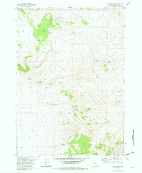
1981 Map of Ibex Butte
USGS Topo · Published 1982About this map
High desert volcanic features and early 1980s water management infrastructure dominate this portion of Crook County. The terrain is defined by dramatic escarpments such as Sherman Rim and Rodman Rim, which flank several prominent volcanic landforms including Ann Butte and the central Ibex Butte. This arid landscape reveals a network of vital water resources essential for livestock and local wildlife, from natural features like Rickman Spring and Willow Springs to man-made developments like Twelvemile Res No 3 and Sartain Res No 2. Evidence of historical land use is visible at Corral and several waterholes, including the Santry Waterhole and Mills Waterhole. The map also captures several distinctive high points like Kid Peak and Willow Butte, providing a detailed look at the relief and remote ranching infrastructure of Central Oregon before the turn of the century.
Find a feature on this map
24 named features on this map. Tap any name to fly to it.
Don’t see what you’re looking for? This feature index may not catch every label — zoom into the map to look around manually.
Map Details
Editions of this 1981 Ibex Butte Map
This is the sole edition of this map. No revisions or reprints were ever made.
Other maps of this area

1955 · Crescent
USGS Topo · 1:250,000

1955 · Burns
USGS Topo · 1:250,000

1957 · Crescent
USGS Topo · 1:250,000

1958 · Crescent
USGS Topo · 1:250,000

1958 · Burns
USGS Topo · 1:250,000

1959 · Burns
USGS Topo · 1:250,000

1970 · Crescent
USGS Topo · 1:250,000
1981 · Mackey Butte
USGS Topo · 1:24,000
1981 · Hardin Ranch
USGS Topo · 1:24,000
1981 · Twelvemile Reservoir
USGS Topo · 1:24,000