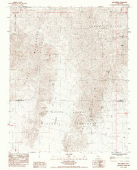
1985 Map of Ibex Spring
USGS Topo · Published 1985About this map
Death Valley National Monument encompasses much of this desert landscape, where the Black Mountains and Ibex Hills meet the boundary of Inyo Co and San Bernardino Co. This 1980s survey details a high concentration of mining activity scattered across the arid terrain, ranging from the American Mine in the north to the Monarch Mine near the center. The presence of Ibex Spring and the associated Ibex Spring Road highlight the critical role of water sources in sustaining prospecting and transit through the Talc Hills. The map traces numerous drainage patterns such as Confidence Wash and Buckwheat Wash, illustrating the seasonal watercourses that define the region's geomorphology. For those researching the mining history of the Mojave Desert, the map identifies specific locations like the Rusty Pick Mine, Eclipse Mine, and Wonder Mine, providing a precise look at the industrial footprint during this era.
Find a feature on this map
25 named features on this map. Tap any name to fly to it.
Don’t see what you’re looking for? This feature index may not catch every label — zoom into the map to look around manually.
Map Details
Editions of this 1985 Ibex Spring Map
This is the sole edition of this map. No revisions or reprints were ever made.
Other maps of this area

1933 · Avawatz Mountains
USGS Topo · 1:250,000

1947 · Trona
USGS Topo · 1:250,000

1948 · Trona
USGS Topo · 1:250,000

1948 · Leach Lake
USGS Topo · 1:62,500

1948 · Avawatz Pass
USGS Topo · 1:62,500

1950 · Confidence Hills
USGS Topo · 1:62,500

1951 · Avawatz Pass
USGS Topo · 1:62,500
1951 · Leach Lake
USGS Topo · 1:62,500

1951 · Shoshone
USGS Topo · 1:62,500

1953 · Trona
USGS Topo · 1:250,000