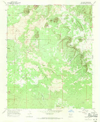
1967 Map of Ice Caves
USGS Topo · Published 1971About this map
Cerro Bandera and the surrounding volcanic landscape of El Malpais define this late-1960s survey of the high desert. The map captures a high-altitude wilderness where the Continental Divide winds through the Cibola National Forest, crossing a complex terrain of prehistoric volcanic activity. Notable geologic features include the Bandera Crater, Lava Crater, and the Twin Craters, which stand as prominent landmarks above extensive fields of Lava.
Find a feature on this map
19 named features on this map. Tap any name to fly to it.
Don’t see what you’re looking for? This feature index may not catch every label — zoom into the map to look around manually.
Map Details
Editions of this 1967 Ice Caves Map
This is the sole edition of this map. No revisions or reprints were ever made.
Other maps of this area

1883 · Mt. Taylor
USGS Topo · 1:250,000

1886 · Wingate
USGS Topo · 1:250,000

1886 · Mt. Taylor
USGS Topo · 1:250,000

1892 · Wingate
USGS Topo · 1:250,000

1892 · Mt. Taylor
USGS Topo · 1:250,000

1899 · Mt. Taylor
USGS Topo · 1:250,000

1917 · Broom Mountain
USGS Topo · 1:125,000

1952 · Valle Largo
USGS Topo · 1:24,000

1952 · Paxton Springs
USGS Topo · 1:24,000

1954 · Saint Johns
USGS Topo · 1:250,000