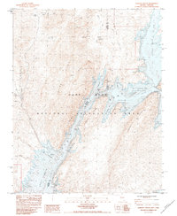
1983 Map of Iceberg Canyon
USGS Topo · Published 1984About this map
Lake Mead National Recreation Area dominates this early 1980s landscape, where the waters of the Colorado River meet the complex geology of the Nevada-Arizona border. The map illustrates a high-water environment within Gregg Basin, featuring numerous intricate inlets such as Devils Cove, Lime Cove, and Sunfish Cove. The rugged elevation is defined by Iceberg Ridge and Wheeler Ridge, providing a sharp contrast to the submerged topography of the Iceberg Canyon itself. To the north, the arid terrain of the Milton Hills and Million Hills is etched with drainage patterns like Connoly Wash and New Spring Wash, leading toward isolated water sources including Connoly Spring. The survey clearly delineates the fluctuating nature of the shoreline, noting the normal pool and spillway elevations near landmarks like Driftwood Island and Cormorant Cliffs.
Find a feature on this map
40 named features on this map. Tap any name to fly to it.
Don’t see what you’re looking for? This feature index may not catch every label — zoom into the map to look around manually.
Map Details
Editions of this 1983 Iceberg Canyon Map
This is the sole edition of this map. No revisions or reprints were ever made.
Other maps of this area

1886 · Saint Thomas
USGS Topo · 1:250,000

1886 · Mt. Trumbull
USGS Topo · 1:250,000

1892 · Mt. Trumbull
USGS Topo · 1:250,000

1893 · Saint Thomas
USGS Topo · 1:250,000

1926 · Bonelli
USGS Topo · 1:96,000

1953 · Iceberg Canyon
USGS Topo · 1:62,500

1953 · Gold Butte
USGS Topo · 1:62,500

1953 · Grand Canyon
USGS Topo · 1:250,000

1954 · Las Vegas
USGS Topo · 1:250,000

1957 · Las Vegas
USGS Topo · 1:250,000