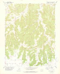
1978 Map of Icehouse Canyon
USGS Topo · Published 1978About this map
Clardy Ranch stands as a lonely outpost in this 1970s landscape, illustrating the remote ranching life of southern Colorado. The terrain is deeply incised by a network of drainage systems including Icehouse Canyon, Tafoya Canyon, and Piñon Canyon, where water sources were critical for survival. Evidence of these vital points is found at Gatlin Waterhole and Twentymile Waterhole, alongside numerous unnamed springs and the January Spring.
Find a feature on this map
33 named features on this map. Tap any name to fly to it.
Don’t see what you’re looking for? This feature index may not catch every label — zoom into the map to look around manually.
Map Details
Editions of this 1978 Icehouse Canyon Map
This is the sole edition of this map. No revisions or reprints were ever made.
Other maps of this area

1891 · Higbee
USGS Topo · 1:125,000

1891 · Timpas
USGS Topo · 1:125,000

1891 · Mesa De Maya
USGS Topo · 1:125,000

1892 · Mt Carrizo
USGS Topo · 1:125,000

1893 · Higbee
USGS Topo · 1:125,000

1893 · Mesa de Maya
USGS Topo · 1:125,000

1894 · Timpas
USGS Topo · 1:125,000

1955 · La Junta
USGS Topo · 1:250,000

1958 · La Junta
USGS Topo · 1:250,000

1968 · La Junta
USGS Topo · 1:250,000