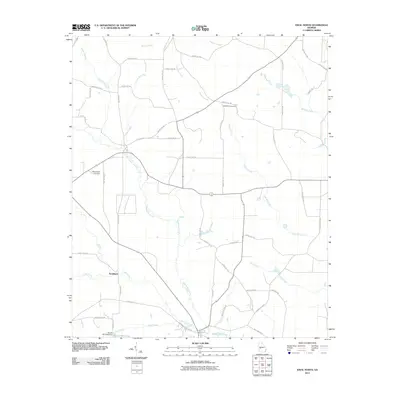
2011 Map of Ideal North
USGS Topo · Published 2011About this map
Whitewater Creek meanders through the heart of this rural Georgia landscape, defining the hydrology of an area north of the town of Ideal. The settlement of Southland sits in the southwestern portion of the map, situated near the confluence of several local waterways including Cedar Creek and Sand Creek. In the southern reaches, the Brooks Mill Pond Dam holds back the waters of Brooks Mill Pond, a notable landmark for those tracing local industrial or agricultural heritage. The rural road network, largely composed of county routes like County Rd-190 and Garden Valley Rd, connects dispersed family farms and community sites. Genealogists will find interest in the Bethlehem Cemetery and Mount Sinai Cemetery, which serve as physical anchors for the area's residents.
Find a feature on this map
53 named features on this map. Tap any name to fly to it.
Don’t see what you’re looking for? This feature index may not catch every label — zoom into the map to look around manually.
Map Details
Editions of this 2011 Ideal North Map
This is the sole edition of this map. No revisions or reprints were ever made.
Other maps of this area

1955 · Phenix City
USGS Topo · 1:250,000

1957 · Phenix City
USGS Topo · 1:250,000

1958 · Phenix City
USGS Topo · 1:250,000

1971 · Rupert
USGS Topo · 1:24,000

1971 · Ideal South
USGS Topo · 1:24,000

1971 · Reynolds
USGS Topo · 1:24,000

1971 · Ideal North
USGS Topo · 1:24,000

1971 · Ellaville North
USGS Topo · 1:24,000

1971 · Garden Valley
USGS Topo · 1:24,000
1971 · Butler West
USGS Topo · 1:24,000