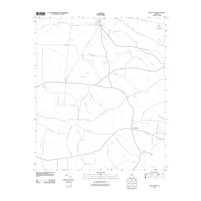
2011 Map of Ideal South
USGS Topo · Published 2011About this map
The town of Ideal sits at the northern edge of this agricultural landscape in Macon County, where a network of rural roads connects scattered homesteads and water resources. The terrain is defined by the winding paths of Buck Creek and Camp Creek, which drain the lowlands of central Georgia. Near the settlement of Fountainville, the landscape reveals a history of local land use at English Millpond and the nearby English Cemetery, providing valuable points of interest for genealogists tracking families in this area. To the northeast, the impounded waters of Kennedy Lake are held by the Kennedy Lake Dam, marking a point of modification along Whitewater Creek. Many routes through the quadrangle bear family names such as Gene Wilburn Rd, Jake Smith Rd, and Ralph Smith Rd, reflecting the deep-rooted personal history and lineage of the surrounding farms.
Find a feature on this map
49 named features on this map. Tap any name to fly to it.
Don’t see what you’re looking for? This feature index may not catch every label — zoom into the map to look around manually.
Map Details
Editions of this 2011 Ideal South Map
This is the sole edition of this map. No revisions or reprints were ever made.
Other maps of this area

1955 · Phenix City
USGS Topo · 1:250,000

1957 · Phenix City
USGS Topo · 1:250,000

1958 · Phenix City
USGS Topo · 1:250,000

1971 · Rupert
USGS Topo · 1:24,000

1971 · Ideal South
USGS Topo · 1:24,000

1971 · Ideal North
USGS Topo · 1:24,000

1971 · Ellaville North
USGS Topo · 1:24,000

1971 · Garden Valley
USGS Topo · 1:24,000

1971 · Montezuma
USGS Topo · 1:24,000

1972 · Ellaville South
USGS Topo · 1:24,000